Lower Colorado River Backwaters
Lower Colorado River Backwaters Vegetation Mapping, Restoration, Model Validation, Habitat Creation, and Biological Assessments
 BIO-WEST led an effort to map vegetation by community dominance/sub-dominance and vertical structure along 600 miles of the lower Colorado River in Arizona, California, and Nevada. Mapping efforts were conducted using remote sensing techniques and high-resolution aerial photography. Additional work included the development of species profiles that describe project area-specific habitat requirements for riparian-wetland and marsh-related threatened and endangered species. The species profiles helped define criterion to be used in the restoration of thousands of acres of habitat for all species of concern.
 BIO-WEST surveyed six backwater habitats using the parameters identified in the backwater evaluation and ranking process associated with the Lower Colorado River Multi-Species Conservation Plan (LCR MSCP). The history of native fish introductions in these sites is known, which helps determine whether numerical biological scores produced from the backwater evaluation and ranking process are consistent with the success or failure of native fish introductions at those sites and the judgment of fisheries biologists. All sites selected for model validation were previously stocked with endangered razorback sucker (Xyrauchen texanus) and/or bonytail chub (Gila elagans), and these introductions varied from being highly successful to unsuccessful.
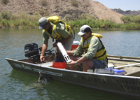
Field data were gathered during summer 2006 to capture the hottest, most stressful time periods for fish. From that data BIO-WEST determined whether the proper variables were considered in the model in order to evaluate the factors most important in selecting backwater sites as cost-effectively as possible. BIO-WEST also provided recommendations for modifying model criteria and the associated ranking categories as determined pertinent through these field efforts and data analyses.
 The backwaters restoration component involved efforts to define ranking criteria that were used to identify potential backwater restoration projects in the lower Colorado River in Arizona, California, and Nevada. This work included the development of a detailed ranking and restoration site selection process that helped define the direction of future restoration efforts on the lower Colorado River. By using species-specific habitat requirement information, this project identified priority areas for habitat restoration/creation of 360 acres of backwater habitat to be designed specifically to benefit razorback sucker, bonytail chub, and flannelmouth sucker (Catostomus latipinnis).
BIO-WEST is currently developing conceptual habitat creation plans and completing biological and water quality site assessments of two backwater sites within LCR MSCP Reach 5. Components of this project include: determining design criteria; developing a set of conceptual alternatives to improve/create endangered fish habitat within the lakes; assessing site development and maintenance costs for each alternative; quantifying the amount of expected habitat creation for LCR MSCP-covered species under each alternative; conducting site visits to collect biological, vegetation, and water quality data; and producing project reports.

